

19–25 September 2025
Route: Biasca – pass di Giümela – passo del Laghetto – Lago di Luzzone – Rabius – Rueun – Panixerpass – Segnas Sura – Versam (near Chur); ~140 km
This trip to Swiss Alps was conceived as a natural follow-up for a conference in northern Italy. I planned to start from the southermost Swiss canton of Ticino and march towards Sargans, a town on the main railway line from Zurich to Innsbruck, from where I would catch an overnight train to Vienna, my next destination. A broad-brush plan called for a 8-day hike, details to be worked out on the way.
I set off from Como in early morning and in 1.5h reached the starting point of my journey in Biasca (a town on the Milano–Zurich railway line near the southern end of the St.Gotthard base tunnel). The first few hours were a warmup – an accent of nearly 2000m from the Ticino valley to a pass named Forcarella di Lago; true to its name, a nice lake with small fishes lied just below the pass, inviting for a dip (the weather was warm and sunny). The warmup phase continued along northern slopes of the ridge, through another pass (Senda del Bò) towards a mountain cabin (rifugio) a kilometer away from pass di Giümela, which I reached already in near darkness. It was still warm and calm, so I slept under the starry skies (the only time in this journey).
The plan for the second day was to start the traverse of the ridge that runs north between Orin and Calancasca valleys, which reaches heights over 3000m and culminates at Rheinquellhorn, a mountain near the source of the Rhine (or rather, one of its branches, Hinterrhein). There is a marked trail that runs along this ridge, so I knew it must be passable without any alpinist gear. I would not be able to complete the traverse in one day, so a good stopover would be between Cima dei Cogn and Cima Rossa, where the trail slightly descends from the ridge onto a high hanging grassy valley. (In general, the topography of these mountains is determined by former glaciers, so when two valleys merge, the mass of the glacier becomes higher and it carves out a deeper valley; tributaries often drop sharply from high cliffs before reaching the confluence).
This plan mostly worked, except that at the beginning of the traverse, I was lead astray by multiple animal trails and lost the marked trail that sharply accended the ridge, so had to find the way up across some couloirs and scree slopes under steep cliffs. Fortunately, upon reaching the seemingly impassable ridge, the trail magically reappeared and carefully navigated all obstacles, only occasionally requiring some scrambling. The views on both sides were exciting, and I could see peaks over 4000m (Monte Rosa and Finsteraarhorn) at a distance over 70 km. I reached my intended stopover point before dusk, still under the same nice weather conditions, but some clouds started to appear on the horizon.
The night was quiet, but in the morning the next mountain on the ridge was already in a cloud. Thus it made little sense to continue the traverse, and it could well become unsafe if the cloud is too dense to see the marked path (indeed, the ridge remained in clouds for the next few hours that I could see it). So I switched to the alternative plan, descending back into the Orin valley. The trail first follows the edge of this deep valley, with seemingly vertical cliffs dropping many hundreds metres, then descends along one of smaller creeks, somehow finding a gradual passage through the cliffs. At some point I switched to a shortcut secondary trail near the bottom of the valley, but lost it and tried to descend directly through the forest. It was okayish for a while, and fortunately I was above the trail, so eventually intercepted it, but looking back from the valley floor, it was clear that my path through the forest would have ended on a cliff if not for the trail. Basically the lesson is to return to the trail immediately after losing it, the terrain is unforgiving!
The end of the descent along the creek was marked by a sleek waterfall, which is not even shown on the map! And under this waterfall was another nice pool for bathing, while the weather is still warm. Then continuing north, up the Orin valley, I reached the next pass del Laghetto, named after a small lake that sits right on the watershed. Its topography is also quite unusual: the trail climbs up a couloir with a tiny brook running through the boulders, reaches the pinch point that appears to be the pass itself, and then one suddenly sees the lake on the other side of the ridge, which gives rise to this brook, while the actual watershed is a very gentle plateau north of the lake, rising a few metres above its level. I though this is the main Alpine watershed, but was wrong (the real one is even less dramatic!..)
From that point, the trail descends to an alpine hut (Capanna Adula) that sits on the valley slope. This is a fairly large hut (unlike the one on the first day, which had essentially one room): this one had two floors and space to sleep a few dozen, but was totally empty. At this point my planned route had a bifurcation: either continue northwest, descending into a long and shallow Carassina valley, or turn northeast along a more mountaneous trail that runs high along slopes and eventually crosses the main ridge to the east. This other option was again disfavoured by clouds on the ridge; I could have stayed in the hut to see how the weather comes out tomorrow, but it was still a bit early (a few daylight hours remaining), so I chose the western variant. A peculiar feature of this Carassina river is that it gushes out of a water tunnel that captures the upper part of the Orin river and transports it under the ridge. (Another common part of Swiss hydrography is that rivers are often diverted across large distances, collecting the flow of many streams into accumulating reservoirs. Then it is not simply let through the dam, which is usually around 100–200 metres high: instead, the water is sent through another tunnel with an exit point much further down in some main valley, so that the effective dam height for the turbines is often many hundred metres. Switzerland gets over half of its energy through hydropower, while using relatively little area for reservoirs). So in this case, after flowing for a few km along the shallowly descending valley, this river ended in an artificial lake, and then sent into a much larger Lago di Luzzone, which I saw on the next day. A forest next to this small lake was a good place to camp; right after putting up the tent, the cloudy weather of the entire day eventually turned into rain, which continued throughout the night (even with a thunderstorm!)
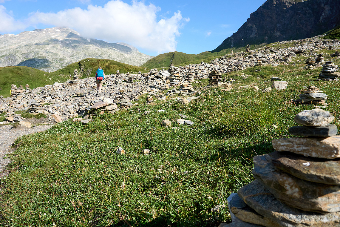
The next day I woke up in a puddle: the tent was unwisely placed in a small depression, so the first task was to relocate it by a few metres, and then I waited in vain for the rain to subside, eventually starting a couple of hours later than usual. The trail looked strange on the map, and soon it became clear why: the sections before the Luzzone lake and then along its southern edge were in tunnels! – a good way to escape the bad weather (though the water also drips from the ceiling). At the northeastern end of the lake, the trail continues through a short but very beautiful canyon with polished rocky walls – and a freight ropeway to the Motterascio cabin high above in the sky! (many of these cabins have some means of delivering goods in absence of roads). After this cabin, the valley becomes very flat and marshy (augmented by the continuing rain and thoroughly obscured by clouds). Somewhere in the middle of this unremarkable landscape lies an unexpected landmark: a “city of cairns”, where over a hundred cairns big and small are towering above the flat terrain. I also added a miniature five-storey one; there are enough flat stones in this area to continue the urbanisation. Shortly after it, the main Alpine watershed is marked by a cross at Crap la Crusch. The water from the marsh probably flows into both Mediterranean and the North Sea.. Meanwhile I continue past another cabin (Terri), descending along one of the many rivers that have Rhine in its name – Rein da Sumvitg. Trying to outrun another rainy cloud appearing from nearby valley – of course I lost the race and had to put up the already wet tent under a downpour..
Fifth day starts the second half of my journey, and I am still south of the dividing line – Anterior Rhine (Vorderrhein). I reach it after a couple of hours mostly walking on roads, and arrive at the Rabius station of the Rhaetian railway. This remarkable narrow-gauge railway runs west from Chur, crosses the St.Gotthard base tunnel some 1000 metres above it (i.e. on the ground level) and continues through Oberalp and Furka passes towards Zermatt. I originally did not intent to use it, my planned route running on trails across the northern slopes of the valley. But even these slopes are now covered in clouds and drenched in drizzle, so while I was snacking, an eastward train arrived and I could not resist the temptation to shortcut a dozen kilometres. In fact, I overshoot: the train stops on demand on some stations, and I couldn't find the “stop request” button in time.. But getting off at the next station (Rueun) was even more convenient, as the route towards the next intended Pass dil Veptga (Panixerpass) starts right from here. The first segment to the village Pigniu (Panix) is on a paved road, and to escape it, I venture onto one of many zigzagging roads that serve nearby farms – without a map for this unplanned section, I again face some navigational challenges, but eventually find my way to this village. The views from the slopes are quite spectacular – a mix of clouds and sunshine, complemented by the incessant ringing of bells attached to each of the many cows pasturing below. After the village, the ascent continues along an unpaved road, and at some point an unremarkable barn on this road bears a remarkable inscription: it turns out that this pass was used by the Russian army led by Suvorov during the Napoleonic wars (in Autumn 1799). This legendary crossing of the Alps under extremely tough terrain and weather conditions is a common figure of speech (much like Hannibal's feat two millenia earlier), and now I could really appreciate the challenge.
Last part of the ascent was again under a rain and some wind, so I was very much relieved by the sight of the small hut sitting on top of the pass. It turned out that there were already two other hikers (one from Germany, another from Slovakia), so we spent the evening sharing stories of our travels (and even some movies! – the dubious advantage of carrying a laptop on a mountain hike after a conference).
Already by nightfall, the rain turned into snow, and by next morning the ground was covered by a few centimetres of white freshness – and shining under the sun! I decided to try out the next mountaneous trail along the ridge eastward to Vorab. Unfortunately, it is difficult to keep track of the trail – most marks are on horizontal stones and thus covered by snow. Nevertheless, I climb up a couple hundred metres, before being stopped by a series of towers. Unable to find a safe (or even marked) passage through wet snow-covered boulders, and in view of another advancing cloud, I abandon the traverse of the ridge and instead descend south, intercepting the trail that runs along the southern slopes of this ridge. The ridge itself soon becomes covered by clouds, vindicating my escape. This area is apparently a large winter resort with many ski lifts in various directions, and in the “summer” it is mostly a series of undulating pastures. Too late in season for the cows, but many of their trails criss-cross the terrain in all directions, and it is again difficult to find the trail. Not that it makes much difference, since the marked path is just another cow trail, but the challenge of tracking the infrequent painted poles protruding above the grass covered by a few centimetres of snow is interesting, and reminds me of the trip to New Zealand, when the speed difference between the trail and bushwhacking was easily a factor of three.. After Fuorcla da Sagogn this garden of forking cowpaths transitions to a more well-defined trail with an occasional cyclist and other animals such as deers and marmots.
Apart from pastures, there are a few more remarkable geological features: some parts look like volcanic lava fields with brooks running in deep undulating crevasses; others are flat polished rocky surfaces; and towards the end of the day, two valleys descending from Piz Segnas with remarkably flat beds created by former glaciers and now threaded by braided creeks. The surrounding mountains also have a very clear horizontal line across several peaks, apparently separating different rock types – it almost looks like a traverse footpath across an impossibly steep slope. This unusual feature is the Glarus thrust fault, in which the older rocks lie above the younger ones, having been shifted horizontally by tens of kilometres. The whole area, together with the nearby Flimserstein, is actually a geological nature reserve declared a UNESCO world heritage site!
Anyhow, the master plan was to continue northeast while staying near the top of the ridge, and I would need to cross the Sardona pass. It does not have an “official” marked trail on the map, but is featured prominently on the Strava heatmap, and from the conversation in the hut the previous evening I learned that the path through cliffs (on the east) and glacial moraine (on the west) is actually marked. However, this was before the snow; now it may be more difficult to find these marks, and I was not looking forward to descending without them over the slippery snowy cliffs. By the time I arrived at the glacial moraine below the pass, it started to be covered by clouds, and the time was running out – I decided to camp at the plains near the moraine end, and try luck tomorrow. This is of course a very open area, and my tent is lightweight and not very suitable for windy weather, so I spent quite some time fortifying it by extra ropes and stones on top of pegs, recalling my first trip to Swiss Alps, in which I had quite a struggle with the ind. Fortunately, the night was calm, and I'm glad that the tent stability test was cancelled.
In the morning, however, the tent and surrounding landscape were under a few more centimetres of fresh snow, and the pass was still in clouds. Weighting my options, I decided to abandon the Drang nach [Nord-]Osten across the ridge, and instead turn south and finish in the Vorderrhein valley, where another interesting geological feature awaited attention: Flimstein – a massive landslide that occurred some 10000 years ago and created a pile of rubble several hundreds of metres high, blocking the valley. Once the river fought its way through the debris, it created a beautiful gorge named Ruinaulta. Even this descent was not without adventures: as soon as I reached the top of the Fil de Cassons plateau, an instantly appearing cloud caused a complete whiteout, in which I could not see a 30° upward slope at all until literally hitting a wall. A 60° downward slope would've been a more precarious story! Fortunately, the trail was still discernible under snow, and eventually I got below the snow line and then onto a paved road from Bargis. A small detour brought me to the ruins of a 12th century Belmont castle on a rocky outcrop above the Rhine valley. The views from there could be amazing, if not for a dense cloud that reached almost to the bottom of the valley. And in the end, the Ruinaulta gorge was filled with both clouds and rays of sun, creating a dramatic atmosphere not unlike the famous painting by Caspar David Friedrich.
Finishing a day earlier than planned, I had time to explore the town of Chur – the capital of the Graubünden canton, with a couple of lovely museums: local history & culture and the art museum showcasing the work of the Giacometti family, who originate from this canton: the most famous of them is Alberto, but his brother Diego, their father Giovanni and uncle Augusto are also very interesting artists.
Although the original plan turned out to bee way too ambitious, unlikely to be fully realized even in perfect weather, the trip was still great even in the reduced form. I am always amazed by the high alpine trails over seemingly impossible or at least very challenging terrain, like traverses of high ridges and steep slopes, but it is vitally important to not lose the trail! and in the snow this becomes a problem. Probably a slightly earlier timing, after the end of the summer rush but before the onset of snow, would be ideal – but snow is also fun! I wonder if it makes sense to go for a winter crosscountry ski trip, or it would feel strange among the hordes of alpine skiers..